


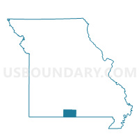
Jackson Voting District, Ozark County, Missouri
About
Outline

Summary
| Unique Area Identifier | 609292 |
| Name | Jackson Voting District |
| County | Ozark County |
| State | Missouri |
| Area (square miles) | 46.43 |
| Land Area (square miles) | 46.32 |
| Water Area (square miles) | 0.11 |
| % of Land Area | 99.77 |
| % of Water Area | 0.23 |
| Latitude of the Internal Point | 36.76374680 |
| Longtitude of the Internal Point | -92.40020710 |
Maps


Graphs
Select a template below for downloading or customizing gragh for Jackson Voting District, Ozark County, Missouri


Neighbors
Neighoring Voting District (by Name) Neighboring Voting District on the Map
- Barren Fork Voting District, Ozark County, MO
- Bridges Voting District, Ozark County, MO
- Brown Voting District, Douglas County, MO
- Jackson Voting District, Douglas County, MO
- Richland Voting District, Ozark County, MO
Top 10 Neighboring County Subdivision (by Population) Neighboring County Subdivision on the Map
- Richland township, Ozark County, MO (794)
- Barren Fork township, Ozark County, MO (443)
- Pine Creek township, Ozark County, MO (439)
- Jackson township, Ozark County, MO (300)
- Jackson township, Douglas County, MO (239)
- Brown township, Douglas County, MO (236)
Top 10 Neighboring Unified School District (by Population) Neighboring Unified School District on the Map
- Ava R-I School District, MO (9,186)
- Gainesville R-V School District, MO (4,526)
- Dora R-III School District, MO (1,843)